Leith Hill
Green
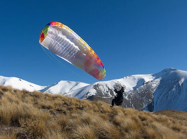
Credit: Michal Klajban

Basic Details
Takeoff GPS -43.21379548534004, 171.6831184328485
Takeoff Altitude: 1384m
Landing GPS -43.20995259655451, 171.7184444797649
Landing Zone altitude: 720m
The Hike
-
Track Start GPS: -43.2094358673063, 171.71205716125579
-
Duration: ~1.5-2hrs
-
Distance / vertical gain: 3-4km / 700m elevation gain
-
Difficulty: Moderate
Notes:
Drive to Castle Hill village. Track start is by DOC sign on Trellisick Loop. Park here, or by toilet block in village (nr LZ)
Follow the track in a CCW direction. The track meanders upwards through beech forest to the treeline on the slopes of Leith hill (~1000m AMSL). From here, bear right off the track and directly up the wide spur through mixed tussock and scree to the summit.
The Takeoff
Terrain:
Mixed tussock grasses and small patches of scree. Gentle gradient, easy abort options
Launch direction:
Most directions NNW, E, S along the wide ridge
LZ visible from TO? Yes


The Flight
-
Min. G.R. to LZ required: 5.5:1
-
Flying over: Trees on lower slopes of Leith hill
-
Hazards: No site-specific hazards
Primary LZ
Large Golf Course on E of main road, immediately opposite entrance to Castle Hill Village
-
Terrain: BIG open flat area covered in grass
-
Wind direction indicators: Small golf flags placed across LZ. Small oxidation pond E of LZ
-
Hazards: Streetlights and lines around the village
-
Hike out: 5mins
Bomb out option: Long Spur
Tips & Hazards
Long spur (North of launch, running E-W) can often trigger light thermals even in winter and can be used as bomb-out landing along the top of the ridge
Alternate flight option over Kura Tawhiti Castle Hill rocks. Landing option South of access track to the rocks (GR ~6.5). Note: landing at the rocks and in the station fields immediately E of castle hill rocks is prohibited. Beware of HT power lines adjacent to main road